


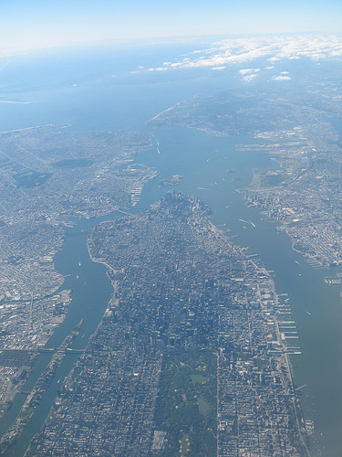
Roosevelt Island can be seen in this aerial photo down by the lower left corner of the photo. This photo looks at NYC from the North looking South.
When you look at a photo like this and can see the topography of the area and the East River you just wonder how Roosevelt Island ever came to be and why the East River as an estuary formed as it did.
The full photo of this view was taken Lazarus6 and can be viewed on Flickr HERE. It is worth linking through to read the location info provided by the photographer if you are unfamiliar with the area.


well, you are looking at 400 years of fill, not the original estuary/bay appearance.
ReplyDeletecoincidentally, i was reading a geological paper last night that proposed that the east and north rivers were formed by glacial runoff weathering out the dolomite from area rock formations. 'course, that was written in 1931, and ideas may have changed somewhat!
The East River isn't an estuary. It is a strait, a water passage between islands or between an island and the mainland. The Hudson is an estuary, tidal and brackish all the way to Albany. The geology of New York City is ancient and fascinating, and reflects the repeated coming-together and then splitting of continental plates, and we're sitting right on top of a lot of it (Roosevelt Island is a unique ridge, of different rock than either adjacent Manhattan and Ravenswood.) Charles Merguerian at Hofstra wrote the book on it: google him. While you're at it, google Cameron's Line, an ancient suture between very different rock formations, which runs parallel to Roosevelt Island down the east channel between us and the power plant. Neat stuff.
ReplyDeletehere is a link to merguerian's geology guide:
ReplyDeletewww.thomsoncustom.com/regional_geology/data/New_York_New_Jersey.pdf